


Earthquake Tears Through Myanmar (Part 3)
Earthquake is unfavorable to the Junta’s governance and military operations

Myanmar’s March 28, 2025 earthquake had unique factors that magnified the scale and severity of the disaster and explain its enormous estimated cost ($75.5 billion). Factors that are unfavorable to the Junta’s governance and military operations. The earthquake was very large, initiated at a relatively shallow depth, ~ 10 kilometers beneath the surface, with fault surface- rupture through the “Bamar Heartland”, that is largely junta-controlled areas (Figure 1). High-population density adjacent to the earthquake source and fault-rupture line, meant intense shaking reached cities, towns, villages, and infrastructure with almost no energy buffering. Satellite mapping indicates the Sagaing fault ruptured a 460 km segment of its 1200 km length. This is a usually long rupture for even a 7.7 M earthquake. Horizontal surface displacement ranged from 3-6 meters, shearing horizontally through structures resting on the fault line. The impact was further magnified by the fault’s location that carved through the economically key and the junta’s militarily important Mandalay-Sagaing-Taungoo corridor and surrounding area. Critical infrastructure such as hospitals, bridges, major roads, railway lines, military bases, government offices, pipelines, power lines and substations near and on the rupture line, were destroyed or heavily damaged. A security camera video caught in real-time the destructive power of fault surface-rupture and the collapse of a high-voltage transmission tower in a junta controlled area.
Compounding the destruction, the earthquake occurred above the eastern-edge of the Central Burma Depression, a 10-20 km thick, vertical-section of sedimentary rocks that makes-up the subsurface. Such settings slow seismic energy, result in amplified ground motion, produce longer duration shaking, and can result in destructive resonance effects on buildings. Examples include destructive earthquakes in Mexico City, Kathmandu, and Los Angeles, all underlain by sedimentary basins. To make matters worse, in many places the Central Burma Depression is capped by extensive flood-plain deposits along the numerous river systems, particularly the large Irrawaddy and Sittaung Rivers. These water-saturated, unconsolidated sediments are notorious for amplifying seismic waves even more than the underlying sedimentary basin, making shaking more violent and prolonged, and raising the possibility of widespread secondary surface-rupture that leads to failure of man-made structures. Seismic energy from the earthquake produced an elongated oval-shaped zone of maximum shaking intensity about 30 km wide and +500 km long that coincides with areas largely controlled by the junta. Within this zone, shaking reached XIII-IX levels on the Modified Mercalli Intensity scale. Levels associated with significant to heavy damage to all structures. It is likely that most buildings experienced peak ground accelerations higher than any local construction standards. Another critical factor contributing to the intense damage was rupture directivity, the amplification of seismic energy in the direction that the fault rupture propagates from the epicenter. The fault-rupture propagated mostly southward along its fault-line from its epicenter, just northwest of Mandalay. Propagation speed was estimated at the incredible rate of 2.5-3.0 km/second and was focused into mainly junta-controlled areas. The event will probably be recognized as a supershear earthquake. These are extremely destructive events, made so by intensified shaking and destruction through a process of wavefront stacking and constructive interference at the tip of rupture propagation. Greater damage reports from Mandalay southward are consistent with this effect. Strong seismic energy also radiated outward as far as several hundred kilometers from the fault line, destabilizing structures and hillsides. Many of the slopes were already vulnerable to failure due to deforestation. With the onset of monsoon season, the steeper slopes are at higher risk of catastrophic landslides and debris flows. The destructive effects will linger for years and will be an enormously expensive challenge for even an effective government to deal with; for instance, China’s 2008 Sichuan Earthquake.
Intense destruction of transport and other key infrastructure within the zone of maximum shaking created obstacles to junta’s military operations and diminishes it resources. The Ava Bridge over the Irrawaddy River, linking the key cities of Sagaing and Mandalay, has partially collapsed, the vital Yangon-Mandalay railway was damaged, the Yangon-Mandalay Expressway and other roads near the rupture have cracked and buckled, river traffic on the Irrawaddy, Sittaung, and other navigable rivers is hindered by collapsed piers, damaged embankments, and broken bridges, Mandalay International Airport sustained structural damage and Naypyidaw’s air traffic control tower collapsed. Critical government and military buildings including several ministries, have been severely damaged. The location and impact of the earthquake diminished the junta’s key economic resources: agriculture, mining, and energy transport. The Myanmar-China oil and gas pipelines cross the fault, and must have suffered some damage given the significant lateral surface-rupture and the intense shaking nearby (Figure 1). At present the pipeline situation is unclear as the junta has a news blackout on damage to key infrastructure and at least one report indicates an opposition force now control a pipeline station near the fault crossing. The pipelines generate an estimated $9.2 billion annually, more than triple the junta’s official $2.7 billion military budget for 2023–2024. Any disruption could significantly impact the regime’s capacity to fund military operations and maintain territorial control. The pipelines have the capacity to carry roughly 440,000 barrels of oil equivalent per day, feeding China's Yunnan province and offering a vital alternative to the Malacca Strait, China’s key energy chokehold.
The concentration of earthquake damage in the “Bamar Heartland” is only part of junta’s post-earthquake challenge. Force posture for the junta’s troops were problematic before the earthquake as it terrain-confined to a narrow, north-south corridor that is poorly defendable from the east and west. Susceptible to ambushes and quick strikes, the now highly-damaged corridor has the potential to splinter from more conventional-military pincer-maneuvers. Tactical operations within the Mandalay-Sagaing-Taungoo corridor must now deal with the destructive aftermath of proximity to the epicenter, surface-rupture, and zone of maximum shaking. Within the corridor are the damaged transportation routes, power lines, and infrastructure that are now obstacles to the historic north-south transportation and communication flow of the “Heartland.” Damage to airfields, supply depots, military bases and command centers have degraded the force posture. Units stationed near the fault suffered casualties, loss of headquarters, barracks, and logistical hubs, were forced to reroute supply routes, and blackouts closed factories producing munitions.
Historically, Myanmar’s military has relied on infrastructure centralization and mobility for fast reinforcement. Coordination between mid-level commands along the long corridor has fractured. The breakdown provides the opposition’s military with more flexibility, operational time, and favorable conditions to scale-up its attacks, whether along the edges of the corridor or in isolated districts. In the short term, the earthquake is not a decisive blow to the junta, but it does improve the opposition’s tactical situation, especially if it can coordinate it operations. Cultural views of the junta need to be considered too, in a nation where astrology and superstition are common. Even within segments of the military the earthquake is seen as a cosmic rebuke against the present junta leadership.
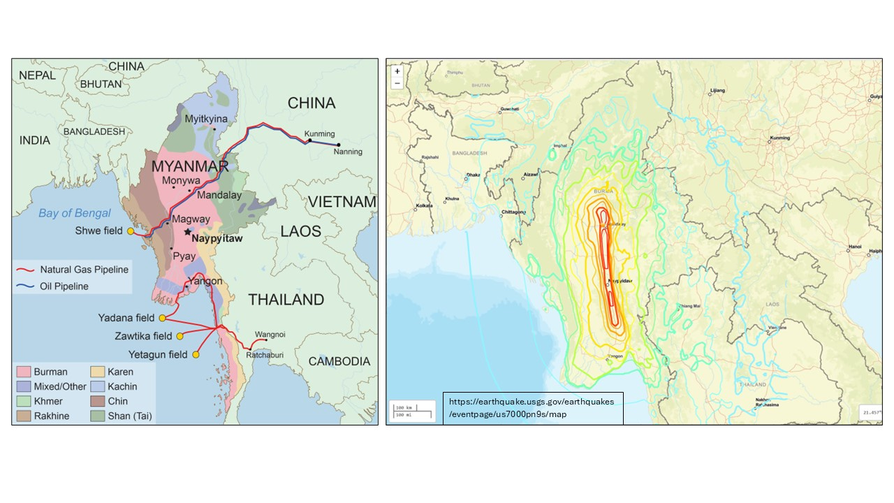
Figure 1. Left map shows the major ethnic groups in Myanmar, offshore natural gas fields, and oil and gas pipelines. The pink-red fill is the Bamar Heartland. Right map shows the oval-shaped zone of maximum shaking intensity concentrated in the Heartland where shaking reached XIII-IX levels on the Modified Mercalli Intensity scale.