


Newsletter 13, Geology along the Pine Mountain Ridge, California
Geo-hike in the Los Padres National Forest, May 10, 2025

Short geology video near the top of Reyes Peak (Elevation: 7517 feet, 2291 meters).
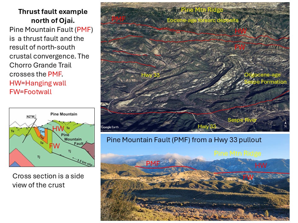
Peak consists of Juncal Formation sandstone. Juncal is mostly deep-marine sandstone, conglomertic sandstone, siltstone, shale and is Eocene in age*. Juncal was part of the extensive forearc-basin that occupied much of the west half of California and Baja California during subduction of the Farallon Plate under North America. From the top of Reyes Peak are great panoramas to the south and north of the western Transverse Ranges, a tectonically active fold and thrust belt. The Pine Mountain Ridge is underlain and formed by a long, east-west trending anticline. Really an anticlinorium as it is is complex map-scale fold. From the top of Reyes Peak and looking east towards Haddock Peak, one can make out a portion of the anticlinal shape with the flat-crest of the anticline in the cliffs just to the south (right) of Haddock Peak, sandstone beds dipping to the left (north) at Haddock Peak, and the steep south-limb of the anticline shown in the steep slopes below the cliffs at Haddock Peak (right). The Pine Mountain Ridge fold is in the hanging-wall of the Pine Mountains Fault and the fold is probably the result on a ramp (bend) in the fault at depth. The fault is exposed at the surface about half-way-up the south limb of the ridge. Both the fault and the hanging-wall fold are probably active, that is deform and uplift during large earthquakes.
The western Transverse Ranges fold and thrust belt are seismically active and the result of north-crustal convergence during the last 3-4 million years. More on the western Transverse Ranges fold and thrust belt here: https://pubs.geoscienceworld.org/gsa/... More in Juncal Formation here: https://en.wikipedia.org/wiki/Juncal_...
In the video I mentioned the Juncal being Paleocene and Eocene. Wikipedia states only Eocene age. I need to research this more.
More on trail to Reyes Peak here: The hike from the trailhead to peak and back is 1.9 miles and 544 ft elevation gain (alltrails.com): https://www.alltrails.com/trail/us/ca... More on Reyes Peak: https://www.peakbagger.com/peak.aspx?...
Note: Three videos were made on May 10, 2025 along the Pine Mountain Ridge. This is the first one. 2d video is just east of Reyes Peak, and 3d video is at Haddock Peak, all on this Youtube channel: https://www.youtube.com/@thomasldavisgeologist61.
Our route for the day: From the end of the Pine Mountain Ridge road (parking area), we hiked first to Reyes Peak via the trail directly to the peak top, and then on to Haddock Peak via a trail that connects back to the main Pine Mountain Ridge trail. We returned to our jeep via the main trail along the Pine Mountain Ridge and by-passed going up Reyes Peak. Our total route was 8.9 miles and 1700 ft elevation gain.