

Geologic map of the San Gorgonio Mountain and Morongo Valley 15' quads, California now available
with brief geologic summary

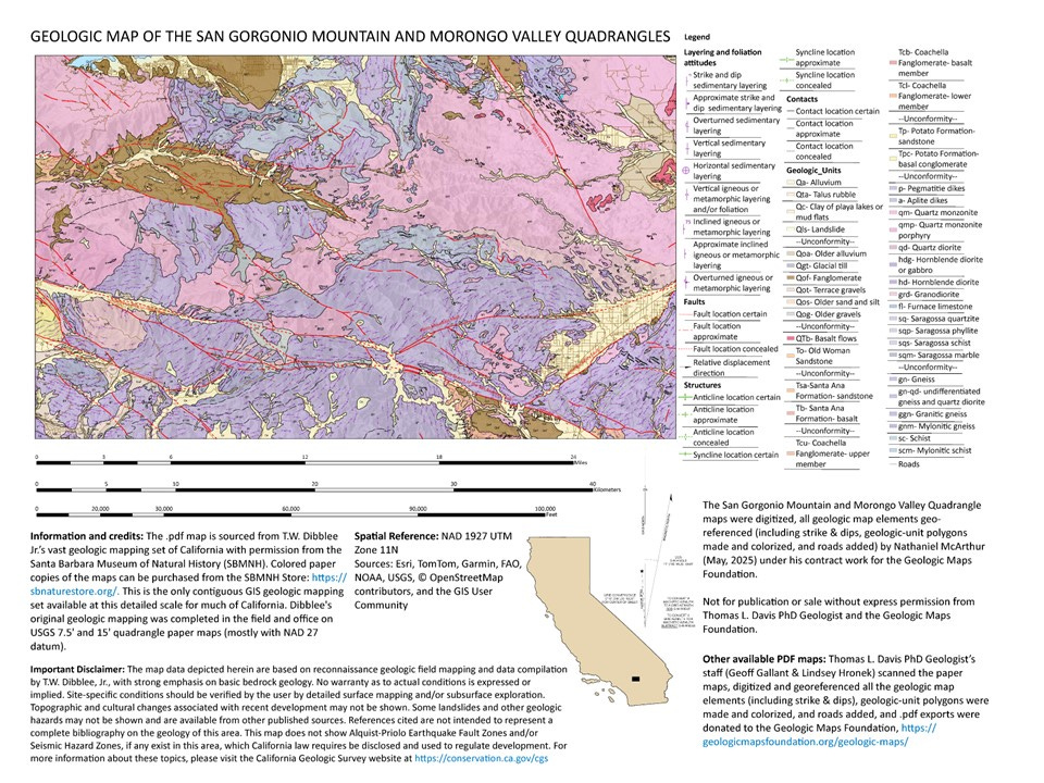
June 23, 2025, the Geologic Maps Foundation, Inc. (GMF) has added its 256th geologic map of California to its web page. The 256th map is the combined San Gorgonio Mountain and Morongo Valley 15' quads, https://geologicmapsfoundation.org/geologic-maps/
To keep this effort going, please consider a donation to the GMF, https://gofund.me/e5ea0696
The original field mapping is from Tom Dibblee's vast mapping collection of California. The San Gorgonio Mountain and Morongo Valley quads are in the eastern portion of the San Bernardino Mountains (eastern Transverse Ranges). Much of the mapped area is high desert mountains with higher ridges and deeper valleys having dominantly an east-west trend. The western half of the mapped area is extremely rugged and remote, despite being close to populated portions of southern California. Within the area are San Gorgonio Mountain (1), the highest peak in southern California, 11,503 feet (3,506 m), the north and south branches of the right-lateral San Andreas fault (2), the present-day North American-Pacific Plate boundary. Proximity to the plate boundary means the entire area is tectonically complex, seismically active and in addition to the San Andreas fault includes several well-known faults including the left-lateral Pinto Mountain (3) and Morongo Valley faults (4)
High-grade metamorphic and quartz-rich granitic rocks occupy a sizable portion of the area and indicate considerable uplift and erosion during the Cenozoic. Sedimentary cover consists of mostly Quaternary-age coarse-grained alluvial, debris flow, and landslide deposits that are the result of the rapid and active uplift of the area. Uplift rates in parts of the San Bernardino Mountains—including the smaller southern fault blocks like the San Gorgonio block—are estimated at ≥ 1.5 mm/yr, reaching 3–4 km of uplift over the past few million years, which averages out to about 1.5 mm/yr or higher (5)
1, https://en.wikipedia.org/wiki/San_Gorgonio_Mountain
2, https://en.wikipedia.org/wiki/San_Andreas_Fault
3, https://scedc.caltech.edu/earthquake/pintomountain.html
4, https://scedc.caltech.edu/earthquake/morongovalley.html
5, https://agupubs.onlinelibrary.wiley.com/doi/abs/10.1029/98TC00378