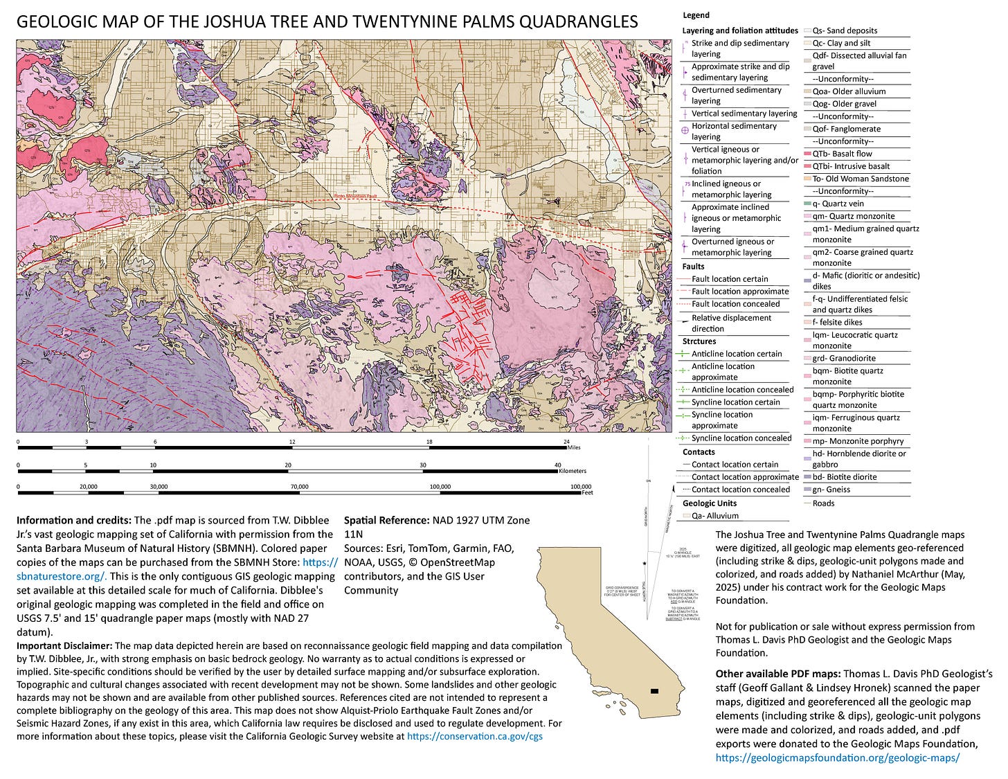
Geologic map of the combined Joshua Tree and Twentynine Palms 15' quads, California, now available
with brief geologic summary
June 26, 2025, the Geologic Maps Foundation, Inc. (GMF) added the combined Joshua Tree and Twentynine Palms 15' quads to its web page. This is the 257th geologic map of California now on its web page. Maps are in .pdf format and free to download, https://geologicmapsfoundation.org/
To keep this effort going, please consider a donation to the GMF,
https://gofund.me/e5ea0696
A few places to visit within the map area for geology:
Pinto Mountain fault crosses the Pioneertown Road and Hwy 247 just north of the town of Morongo Valley. Fault line is along southernmost extent of the granitic outcrops.
Samuelson Rocks you’ll need to do a several mile desert hike from Park Boulevard in the northern portion of Joshua Tree National Park (closest to West Entrance to Park). Hike provides a good look at the foliated granodiorite (grd) and quartz-monzonite (qm1) that occurs across much of the northern portion of the Park. The trail crosses distal alluvial fan deposits of various ages while passing through a variey of desert vegetation. The many unique writings at Samuelson Rocks standout as they were cut into desert varnish developed on the granodiorite.
Hidden Valley Nature Trail is a short and interesting hike through quart monzonite outcrops (qm1). The trail passes through rocks that are in place (in-situ) and large boulders piles that are result of long-term desert-weathering. This trail can get crowded during weekends in peak season.
The original field mapping is from Tom Dibblee's vast mapping collection of California. The Joshua Tree and 29 Palms 15'quads lie just east of the San Gorgonio Mountain and Morongo Valley 15' quads that were added to the Geologic Maps Foundation web page on June 23, 2025. Together the maps provide a contiguous and detailed look at an interesting and geologically complex part of the eastern Transverse Ranges of southern California. Within the mapping are the eastern portion of the San Bernardino National Forest, Sand to Snow National Monument, The Wildlands Conservancy (Whitewater, Galena Peak, Mission Creek, and Pioneertown Mountains Preserves), and the northern half of Joshua Tree National Park. Much of the mapped area is high desert mountains with higher ridges and deeper valleys having dominantly an east-west trend. Sizable portions are extremely rugged and remote, despite being relatively close to urban areas of southern California.
The Joshua Tree and Twentynine Palms area of southern California is geologically complex, recording over 1.7 billion years of earth history through a diverse suite of igneous, metamorphic, and sedimentary rocks. Extensive Cretaceous plutonic bodies, emplaced during subduction of the Farallon Plate, dominate the western and central parts of the map and form the iconic desert-boulder dominated landscape of Joshua Tree. Miocene and Pliocene volcanic flows and intrusions are associated with Basin and Range extension and in number of locations, dark basalt-flows form mesa caps on the light-colored granitic rocks. Quaternary units are unconsolidated sediments including dissected alluvial fans, stream gravels, and aeolian sands. The area is crossed by numerous faults, some active and the San Andreas fault lies just to south of the mapped area. The most significant structure in area is the active, left-lateral Pinto Mountain Fault.


