
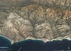

Geo-hike along the Chorro Grande Trail, Los Padres National Forest, western Transverse Ranges, California:
Crossing the Pine Mountain thrust fault from the footwall to the hanging-wall.

Sorry folks, this newsletter is a bit rushed but I wanted to get it out before the Geo-hikes trip to the White Mountains starts tomorrow. We did the Chorro Grande Geo-hike on Saturday (October 1), more with photos at https://www.meetup.com/geo-hikes/events/288719679/
The Chorro Grande trail to the top of the Pine Mountain ridge line shows some convergent structures typical of the western Transverse Ranges fold and thrust belt. North-south crustal convergence has created fold and thrust belt and uplifted and deformed the Transverse Ranges of southern California. Transverse Ranges are seismically active and the source of many of southern California’s destructive earthquakes, i.e., 1994 Northridge, 1971 Sylmar.
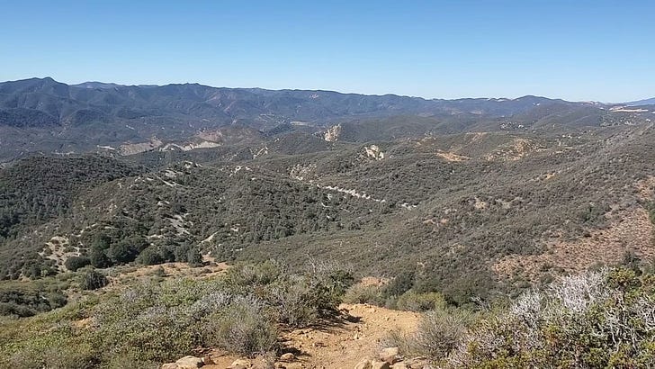
The Chorro Grande trail hike is moderate for those in good hiking shape, nearly 11 miles round trip, plus 3,236 feet up. Trail is along the southern flank of the ridge, well exposed to the sun, steep in places, and hot in the summer and late spring. Take plenty of water and start very early in the summer. During the winter the top of Pine Mountain ridge can have a layer of snow, although not common.
North-dipping hogbacks of Sespe Formation outcrop just above the trailhead along Highway 33. The Sespe Formation is Oligocene age, one of the few non-marine formations in the thick section of upper Cretaceous to Pliocene age, marine sedimentary rocks of the western Transverse Ranges. Good exposure of tan- to reddish-brown sandstone, conglomeratic sandstone, and conglomerate make-up the Sespe Formation along the trail. Notice that many of the Sespe conglomerate clasts (pebbles and cobbles) are well-rounded with many hard rock types like meta-volcanics, gneiss, and quartzite. Most of these clasts are from bedrock sources outside of the area. The rounding, exotic clasts, and various paleogeographic reconstructions indicate the Sespe is the result of an ancient river system that was sourced in eastern California and western Arizona.
The north dip of the sedimentary rocks means that younger formations are encountered along the trail as it heads northward up Chorro Grande Canyon. A thick covering of chaparral covers much of the younger rocks up the canyon but here and there are glimpses of the Vaqueros, Monterey, and Santa Margarita Formations, all marine sedimentary deposits dipping northward.
The trail steepens with switch-backs as the trail crosses the Pine Mountain thrust fault that dips northward under Pine Mountain Ridge. The ridge above is in the hanging-wall block of the thrust and the Sespe and younger formations passed through in the lower canyon are in the footwall block. The hanging-wall block is moving southward, towards the valley with Highway 33, over geologic time. The fault is not well exposed but the trail crossing of the fault zone can be roughly determined by a change in soil color from grayish-white (footwall block) to reddish-brown (hanging wall block).
The trail steepens with a number of switchbacks as it ascends the hanging-wall block that consists of reddish-brown marine sandstone of Eocene age. Pine Mountain ridge is large anticlinorium (an arched upward crustal-scale fold) created by movement on the underlying Pine Mountain thrust, and the Chorro Grande trail traverses the southwest limb of the fold.
The ridge crest is more or less the axis of the fold and has sweeping panoramas of the local ranges. To north is the Cuyama badlands, and to south, on a clear day, can be seen the Pacific Ocean and northern Channel Islands.
THOMAS L. DAVIS PHD PG & ASSOCIATES LEAD AND ORGANIZE GEOLOGIC FIELD TRIPS IN THE SOUTHWESTERN USA AND BAJA CALIFORNIA FOR ORGANIZATIONS, COMPANIES, AND INDIVIDUALS, CONTACT US AT tldavisgeo@gmail.com or geologicmapsfoundation@gmail.com